
Page 29 - JOAMay2021
P. 29
The ease and accessibility of Here’s New England represented a
transitional moment in how travel, and particularly driving, was being
shaped in the 1930s. The Great Depression had made owning a car a
necessary part of livelihood, allowing for families and migrant workers
to find better opportunities out West. By 1931, there were fifty million
automobiles produced, and by 1939 there were seventy-five million,
with car ownership totaling twenty million by 1935. On the other
hand, the country had about 500,000 miles of two-lane highways
during the 1930s, and only about 70 percent of these were paved. The
WPA ended up being responsible for over half a million miles of road
construction during this period. Due to the migration of Americans
west towards California, many viewed the road as a source of anxiety.
In contrast, Here’s New England characterized the region as a place of
safety, calling it “a great playland” for the traveler. This was reinforced
by the reader’s first view of the book: the cover image depicted a log
cabin, nestled by the sea with an island in the distance, and a white
lighthouse welcoming in boats.
Here’s New England
Here’s New England emphasized travel on new and expanded
highway systems, such as US 1-7. US 1 dominated much of their
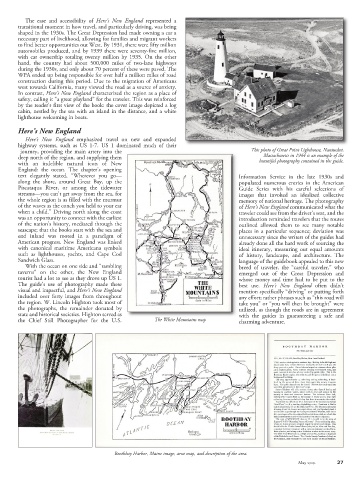
journey, providing the main artery into the This photo of Great Point Lighthouse, Nantucket,
deep north of the region, and supplying them Massachusetts in 1944 is an example of the
with an indelible natural icon of New beautiful photography contained in the guide.
England: the ocean. The chapter’s opening
text elegantly stated, “Wherever you go— Information Service in the late 1930s and
along the shore, around Great Bay, up the populated numerous entries in the American
Piscataqua River, or among the tidewater Guide Series with his careful selections of
streams—you can’t get away from the sea, for images that invoked an idealized collective
the whole region is as filled with the murmur memory of national heritage. The photography
of the waves as the conch you held to your ear of Here’s New England communicated what the
when a child.” Driving north along the coast traveler could see from the driver’s seat, and the
was an opportunity to connect with the earliest introduction reminded travelers that the routes
of the nation’s history, mediated through the outlined allowed them to see many notable
seascape; that the books start with the sea and places in a particular sequence; deviation was
end inland was rooted in a paradigm of unnecessary since the writers of the guides had
American progress. New England was linked already done all the hard work of sourcing the
with canonical maritime Americana symbols ideal itinerary, measuring out equal amounts
such as lighthouses, yachts, and Cape Cod of history, landscape, and architecture. The
Sandwich Glass. language of the guidebook appealed to this new
With the ocean on one side and “rambling breed of traveler, the “careful traveler,” who
taverns” on the other, the New England emerged out of the Great Depression and
tourist had a lot to see as they drove up US 1. whose money and time had to be put to the
The guide’s use of photography made these best use. Here’s New England often didn’t
visual and impactful, and Here’s New England mention specifically “driving” or putting forth
included over forty images from throughout any effort; rather phrases such as “this road will
the region. W. Lincoln Highton took most of take you” or “you will then be brought” were
the photographs, the remainder donated by utilized, as though the roads are in agreement
state and historical societies. Highton served as with the guides in guaranteeing a safe and
the Chief Still Photographer for the U.S. The White Mountains map charming adventure.
Boothbay Harbor, Maine image, area map, and description of the area.
May 2021 27